Espírito Santo do Turvo
You can help expand this article with text translated from the corresponding article in Portuguese. (June 2013) Click [show] for important translation instructions.
|
Espírito Santo do Turvo | |
|---|---|
 | |
 Location of Espírito Santo do Turvo within the State of São Paulo | |
| Coordinates: 22°41′31″S 49°25′48″W / 22.69194°S 49.43000°W | |
| Country | Brazil |
| State | São Paulo |
| Mesoregion | Assis |
| Microregion | Ourinhos |
| Government | |
| • Mayor | João Adirson Pacheco (2009–2012) |
| Area | |
| • Total | 193.655 km2 (74.771 sq mi) |
| Elevation | 520 m (1,710 ft) |
| Population (2020 [1]) | |
| • Total | 4,878 |
| • Density | 25/km2 (65/sq mi) |
| Time zone | UTC−3 (BRT) |
| Website | link |
Espírito Santo do Turvo is a municipality in the Brazilian state of São Paulo. The population in 2020 was 4,878 and the area is 193.655 square kilometres (74.771 sq mi).[2] The elevation is 520 metres (1,710 ft).
History
[edit]This section needs expansion. You can help by adding to it. (June 2013) |
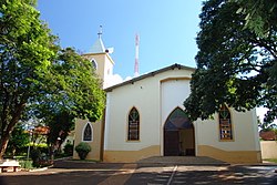
The donation of a tract of land for the construction of a church is the landmark in the history of this city. On 23 March 1878, after significant growth Espírito Santo do Turvo (English: Holy Spirit of Turvo) received the title of Freguesia, a secondary local administrative unit in Portugal, by Law No. 08, and was marked as a Religious Heritage Site. Seven years later, in March 1885, the Law No. 20 raised it to the level of Town.
Government
[edit]This section has multiple issues. Please help improve it or discuss these issues on the talk page. (Learn how and when to remove these messages)
|
- Mayor: João Adirson Pacheco (2009–2012)
Geography
[edit]This section needs expansion. You can help by adding to it. (June 2013) |
Espírito Santo do Turvo is located in the southern-subtropical part of Brazil, at 22 degrees, 41 minutes, 31 second south, and 49 degrees, 25 minutes, 48 seconds west, at an altitude of 520 metres (1,710 ft), in the internal part of the State of São Paulo. It covers an area of 193.655 square kilometres (74.771 sq mi).[2]
- Rivers
Demography
[edit]This section needs expansion. You can help by adding to it. (June 2013) |
Its population in 2020 was 4,878 inhabitants.
- 2000 Census figures[3]
Total population: 3,677
- Urban: 3,241
- Rural: 436
- Men: 1,900
- Women: 1,777
Density (inhabitants/km2): 19.22
Infant mortality up to 1 year old (per thousand): 16.70
Life expectancy (years): 70.78
Fertility rate (children per woman): 2.63
Literacy rate: 87.69%
Human Development Index (HDI): 0.755
- Income: 0.666
- Longevity: 0.763
- Education: 0,835
Economy
[edit]This section needs expansion. You can help by adding to it. (June 2013) |
Its economy is based on agriculture with large production of peanuts and cotton. Espírito Santo do Turvo is an important junction to the south, Mato Grosso, and other regions.
Transport
[edit]This section needs expansion. You can help by adding to it. (June 2013) |
- SP-225 state highway
- SP-280 tollway
- BR-369 highway
Media
[edit]In telecommunications, the city was served by Telecomunicações de São Paulo.[4] In July 1998, this company was acquired by Telefónica, which adopted the Vivo brand in 2012. The company is currently an operator of cell phones, fixed lines, internet (fiber optics/4G) and television (satellite and cable).[5]
References
[edit]- ^ IBGE 2020
- ^ a b IBGE (10 October 2002). "Área Territorial Brasileira – Consulta por Município – Resultados" [Brazilian Territorial Area - Browse by Municipality - Results] (in Portuguese).
- ^ (Source: IPEADATA)
- ^ "Creation of Telesp - April 12, 1973". www.imprensaoficial.com.br (in Portuguese). Retrieved 2024-06-04.
- ^ "Our History - Telefônica RI". Telefônica. Retrieved 2024-06-04.
External links
[edit]- Official website (in Portuguese)
- Associação Paulista de Municípios [Paulista Association of Municipalities] (in Portuguese)
- Censo 2010 at IBGE
- Hino do município de Espírito Santo do Turvo [Anthem of Espírito Santo do Turvo Municipality] (in Portuguese) at Wikisource


